The death toll from the devastating earthquake in Nepal Friday late night (October 4) has climbed to 141, with at least 140 injured individuals successfully rescued from the debris thus far. This information has been officially confirmed by Nepal’s national daily, The Kathmandu Post, citing statements from police officials.
Nepal’s Earthquake Monitoring and Research Center issued a statement on Saturday, indicating that the epicenter of the earthquake was in Jajarkot district, situated 250 miles northeast of the capital, Kathmandu. The United States Geological Survey reported that the earthquake originated approximately 11 miles below the Earth’s surface.
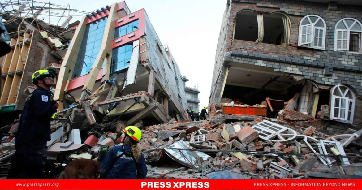
The earthquake has caused significant damage to numerous houses in Nepal, leading to a breakdown in communication in many areas. Government disaster response teams and police have yet to reach several regions, particularly those in remote, hilly terrain.
The most substantial number of casualties occurred in Jajarkot district, which served as the epicenter of the earthquake. Deputy Superintendent of Police Santosh Roka, based in Jajarkot, stated that 44 bodies have been recovered from various locations within the district, which is located 245 miles northeast of Kathmandu, the capital.
Rescue Operation
The rescue efforts are anticipated to progress slowly due to the need for emergency teams to first clear blocked roads resulting from landslides in various areas. Additionally, helicopters and small aircraft have been put on standby to assist in the operation.
Deputy Mayor Sarita Singh of Nalgarh town in Jajarkot, as confirmed by Roka to The Kathmandu Post, is among the casualties. Furthermore, more than 55 individuals have been rescued from different villages and towns within the district in various states of injury.
In the second position on the list of heavily affected areas is West Rukum, a western hill district of Nepal. District Police Deputy Superintendent Namraj Bhattarai reported the recovery of 36 deceased individuals and 85 injured from diverse villages and towns in West Rukum.
Apart from Jajarkot and West Rukum, several other regions in Nepal, including Veri, Nalgarh, Kushe, Berekot, and Chedagarh, have reported extensive damage and casualties, according to government officials as relayed to The Kathmandu Post.
Nepal, often referred to as the ‘Daughter of the Himalayas’ due to its location on the Tibetan and Indian tectonic plates, is susceptible to frequent earthquakes. On October 22, a 6.1 magnitude earthquake struck Kathmandu and its surroundings, resulting in no casualties.

Tibetan and Indian Tectonic Plate
The Indian Plate encompasses a significant portion of modern South Asia, including the Indian subcontinent, and extends into the basin beneath the Indian Ocean. This plate also comprises parts of South China and western Indonesia, but its boundary stops short of regions like Ladakh, Kohistan, and Balochistan.
The formation of the Tibetan Plateau, the world’s highest plateau, is attributed to a tectonic process in which the Indian and Eurasian continental plates collided. This collision gave rise to the unique geological features and structures that have perplexed geologists worldwide within this enigmatic plateau.

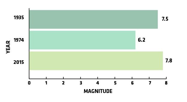
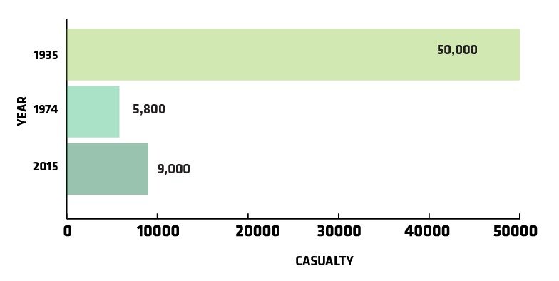
In 1935, a devastating magnitude-7.5 earthquake struck Quetta, India, resulting in the tragic loss of 50,000 lives. In 1974, in close proximity to the recent earthquake’s epicenter, a magnitude-6.2 earthquake occurred, claiming the lives of 5,800 people. However, in 2015, a devastating 7.8 magnitude earthquake claimed the lives of at least 9,000 people and destroyed approximately 1 million homes.

October’s Earthquake in Afghanistan
In October 2023, a powerful earthquake struck western Afghanistan, following a previous quake that claimed the lives of over 2,000 individuals and devastated entire villages in Herat province, marking one of the most destructive seismic events in the country’s recent memory.
The earthquake on October 11 had a magnitude of 6.3 and occurred approximately 28 kilometers (about 17 miles) outside the provincial capital, Herat. It was also relatively shallow, with a depth of 10 kilometers (around 6 miles), as reported by the U.S. Geological Survey. This latest earthquake resulted in at least one fatality and left approximately 120 people injured.
The 2015 Tragic Earthquake in Nepal
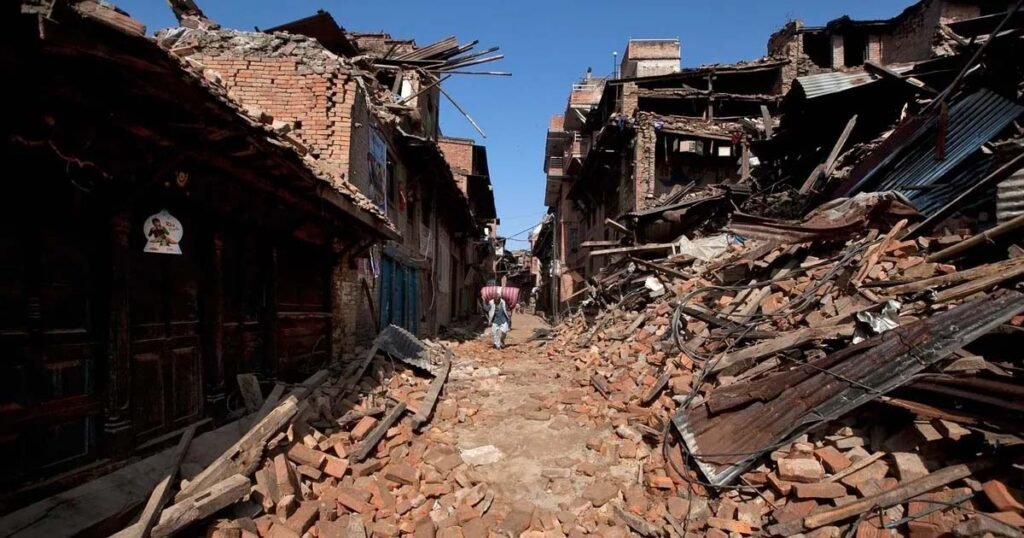
Nepal is situated along a significant geological fault line where the Indian tectonic plate forcefully converges with the Eurasian plate, giving rise to the majestic Himalayan Mountain range. As a consequence of this tectonic activity, earthquakes are a recurrent phenomenon in the region. In 2015, a devastating 7.8-magnitude earthquake struck Nepal, resulting in the loss of nearly 9,000 lives, the destruction of over half a million homes, and injuries to another 22,000 people. Moreover, in November 2022, six individuals lost their lives when a 5.6-magnitude earthquake occurred in Doti district, near Jajarkot. This shallow initial earthquake, with a depth of merely nine miles, generated significant surface tremors. The catastrophe resulted in the collapse of poorly constructed multi-story brick buildings and temples in and around Kathmandu, reducing them to rubble.
Why South Asia Faces a High Earthquake Risk
South Asia stands out as one of the most susceptible regions to a range of climate-related hazards, including cyclones, volatile monsoon rainfall, floods, food and water insecurity, and extreme heat linked to rising temperatures. Numerous geological studies have underlined the heightened earthquake risks in various parts of Asia, with Southeast Asia, in particular, being of great concern. In Southeast Asia, the plate boundary formed by the convergence of the Indo-Australian and Eurasian plates, known as the Sunda Megathrust, poses a substantial risk of seismic activity, including earthquakes and tsunamis.
This peril affects approximately 50 million individuals who reside in areas prone to Himalayan earthquakes, including densely populated regions in countries such as Bangladesh, Bhutan, India, Nepal, and Pakistan. These findings stem from research conducted by scientists from the University of Colorado, published four years ago, which meticulously examined seismic activity within the region.


